ADVENTURE – An exciting, daring, bold, risky or very unusual experience or undertaking fraught with physical, financial or psychological risks.
Any ideas of what to visit in the areas I am traveling would be appreciated, not all sites are noted somewhere, secret spots abound. And if you share these secret spots with me to enjoy I will not post where they are but will relish in the beauty around me and be grateful you trust me with this shared this information.

The next stage of the trip will include a drive along the Icefields Parkway from Banff National Park to Jasper National Park stopping to see Bow Lake, Peyto Lake, Howse Pass Historic Site, Saskatchewan River Crossing, Weeping Wall, Columbia Icefield, TC Falls, Sunwapta Falls and Athabasca Falls.

I will stay a few of nights in Jasper to explore the town and a few of day hikes surrounding the town.
Leaving Jasper I will continue along Canadian National Highway 16 turning northwest along Highway 40 and head toward Dawson Creek, British Columbia, Canada and possibly head west to see the W.A.C. Bennat Dam continuing back to Highway 97 and head north Fort Nelson, BC.

Continuing north toward Watson Lake, Yukon Territoriies to see the Sign Post Forest I will stop to see Muncho Lake Provincial Park and Liard Hotsprings Provincial Park along the way. Leaving Watson Lake I will head along Highway 4 to Carmaks, Yukon Territories then continue along Highway 2 to Stewart Crossing then toward the town of Keno City at the end of the Silver Highway and visit the Keno Hill Mining District.

After exploring Keno Hill I will return to Highway 2 then continue north to the Dempster (edit) Highway stopping to get my photo at the Arctic Circle and visit the town of Invuik. Continuing north along the just opened summer road I will end at the Arctic Ocean and the town of Tukoyaktuk, Northwest Territories, Canada.
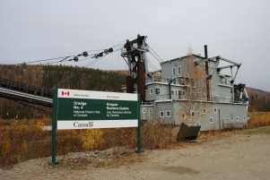
After dipping my toes in the Arctic Ocean I will retrace my steps down the Dawson Highway for a few days of relaxation and rest in Dawson, Yukon Territories. During this relaxation time I will explore the town, the surrounding mining district, Dredge #4, and the Discovery Claim National Historic Site.
Now, how have I found this information? From maps; computer mapping programs; books, searching the specific areas I wish to visit on the Internet (Google is my friend); country, territory and city visitor information sites; and information from other travel bloggers. I have gone to my local bookstore to wander and peruse the shelves looking for interesting travel books of these areas. I will go to my local Automobile Association to find out what information they might have available there. A travel book, map and your time searching are well spent in preparing for a trip. Information gained ahead of the trip will help insure you plan the time to see the sites most important to you.
I will continue with the planning of this adventure in additional posts so please stay tuned.
PART 3 of the Adventure Planning to follow.


We have a few posts on Banff & Jasper on our blog that should give you some good ideas. You already have the main points down, and so many of the hot spots are right off the Icefields Parkway. Looking forward to hearing about your trip!
LikeLiked by 1 person
I’ll check them out, thank you
LikeLiked by 1 person
Sounds good! I love you will be hiking and exploring some towns!
LikeLiked by 1 person
“An exciting, daring, bold, risky or very unusual experience or undertaking fraught with physical, financial or psychological risks.” __ I imagine it’s going to be a combination of them all!!
LikeLiked by 1 person
It shall be fun that is for sure.
LikeLiked by 1 person
I’m jealous.
LikeLike